How GPS Works
The following is a very simple explanation of how GPS works out your position. Many of the technical details that enable it to work have been missed out, but if like me you're a scientist, then a more technical description can be found on the GPS manufacturers' web sites. See the end of this page for links to them.
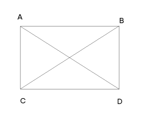
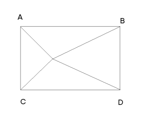
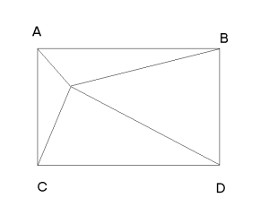
The GPS satellites carry atomic clocks which keep time to a phenomenal level of accuracy, and are regularly cross checked with each other. The satellites send out a time signal at regular short intervals and broadcast details of their orbit at larger intervals, which the GPS units store. In each of the diagrams below, imagine there are GPS satellites at positions A, B, C, and D, and you are standing at the point where the four lines from the corners of the square intersect.
|
Here you are exactly the same distance from each satellite. If all four satellites send out a signal telling you the time, all four signals arrive at the same time. There is no delay between the signals, so the micro processor in the GPS knows that you are the same distance from each of the satellites. If it knows where the satellites are (they tell the GPS details about their orbit at regular intervals) then the GPS can calculate exactly where on earth you are. |
|
In this case you are the same distance from A and C, and the same distance from B and D. So the signals from A and C will arrive with no delay, then a short time later the signals from B and D arrive together. The time delay between the two sets of signals can be used to calculate how much closer to A and C you are than to B and D, and your position along the mid-line can be calculated. |
|
Here all four signals arrive at different times, and from the various delays, and some complicated maths, your position can be found. It's simply a hard version of the calculation for the two examples above. |
In the examples above the four satellites are in exactly the same horizontal plane, and your position is actually somewhere on a vertical line perpendicular to the screen running through the intersection point, with no height information to pinpoint it. But satellites move in three dimensional space and are not in exactly the same plane. As soon as we lift one satellite out of the plane, we can get a position that is a point in space, with height information as well. This is harder to draw and to visualise, so just take my word for it.
GPS at Encarta - this is a general description of the system, not too technical.
Garmin site - What is GPS? - a general introduction, a bit more advanced than the Encarta one.
Garmin site - GPS for Beginners a longer, more detailed, version of the above, from the GPS manufacturer
Trimble site - All about GPS another detailed introduction from a manufacturer. Includes some animations, needs Shockwave.
GPS at WikiPedia - a lot of info and useful links in a large article on GPS
How Stuff Works - GPS - another readable set of pages for the slightly more technically minded.
The Global Positioning System - technical info about GPS. Not recently updated.